KANSAS CITY, Mo — A Winter Weather Advisory has been issued for the Kansas City metro and counties along and east of I-35 for the wintry weather coming Wednesday.
We’re still expecting a couple of different types of precipitation to be falling throughout the day. Temperatures throughout Wednesday will also be tricky and critical for determining snowfall totals.
We’ll start with snow showers coming up from the south overnight Tuesday into Wednesday and finally getting into the I-435 loop by the end of the morning drive, around 7-8 a.m.
Light to moderate snow will continue for the rest of the morning, but will start to transition to a rain/snow mix as temperatures will slowly bump up above 32 degrees around lunch time.
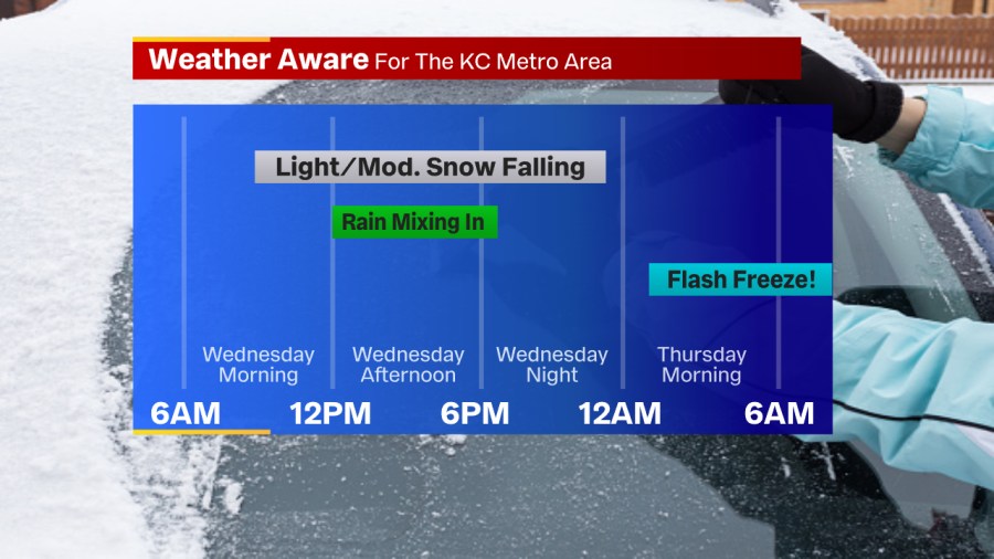
The afternoon warm-up and rain showers will help slowly melt whatever snow there is on the ground. Then, for the late afternoon & evening, as we cool back down again, we’ll switch back to light snow showers with any remaining moisture.
All the precipitation will break down and fade away Wednesday night into early Thursday morning.
Again, snow totals will be entirely dependent on the temperature. Morning lows will be in the low 30s, allowing the snow to fall first. The longer we stay in the low 30s, the better chance we have of holding onto more snow.
If temperatures start warming ahead of schedule, those projected amounts will drop off quite a bit.
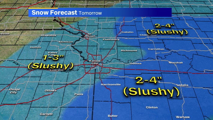
As it stands now, we’re expecting 1-3 inches for the immediate metro, and those areas around I-35. Farther east of KC, that’s where heavier snow is expected so 2-4 inches is more likely. Some melting will occur tomorrow afternoon as well, adding to the mess.
Road conditions will most likely worsen during the mid to late morning hours as the snow starts falling. For the afternoon, it’ll just be a slushy mess more than likely as temps climb above freezing.
Afterward, focus will shift to a flash freezing concern Wednesday night and the noticeable cold blast Thursday and Friday. Morning lows will be into the single digits and highs Thursday won’t even hit the 20s!
Get the latest forecasts Tuesday night and all day Wednesday on FOX4 News and on fox4kc.com. And be sure to download our apps (Apple and Android) and follow us on Facebook.