Good morning…the wettest time of the year is certainly producing right now. An upper level low towards the south of the region is allowing rain to develop and wrap through the region. The atmosphere is loaded with moisture and the clouds are being very efficient in producing rain. Some areas have seen well over 3″ so far…others not nearly as much.
The weather will turn quickly overnight as cooler and drier air flows in but I do have concerns about the weekend that I mentioned yesterday as we’ll be in northwest flow and that means we may be vulnerable to disturbances coming down from Nebraska. The trick will be how well this stuff holds together as it moves towards the southeast.
_______________________________________________________________________
Forecast:
Today: Rainy…there may be breaks every so often but just a real iffy day. Cool as well with highs in the 70-75° range assuming we get some breaks in the rain.
Tonight: Rain ends quickly before sunset and clearing skies moves through. The air will dry out and by daybreak we’ll be in the mid 50s
Tomorrow: Fabulous with highs in the mid 70s
Saturday: Increasing clouds with the threat of some rain developing after 3PM or so coming down from the northwest. We’ll see how far south this makes it but it’s worth watching so that you’re not surprised. Highs in the mid>upper 70s
Sunday: Can’t rule out a few showers/storms but overall it should be a decent day with highs approaching 80°
________________________________________________________________________
Discussion:
Got out and played some golf yesterday with Garry and it was mushy out there. Lots of moisture in the ground and what happened last night and today isn’t going to help that cause at all.
Northside…
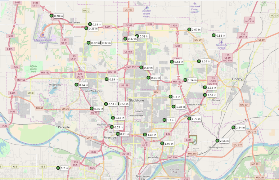
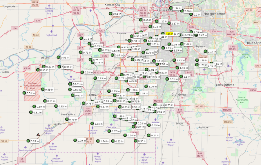
This is one of those systems that unless KCI really gets into some rain…it will go down as a minor event but we’re seeing some localized flooding out there in parts of Jackson, Co today…and KCI through 9AM is under 1/4″ of moisture in the last 24 hours. Just one of those things. There will be more rain out there today.
Here’s radar.

This is all rotating around an upper level storm down to the south of the region.

The data above shows the 500 mb flow…and gives you an idea of the upper level winds that are out there. This is roughly about mid way through the atmosphere.
So you can see the main upper level low spinning away…that will take the rain with it for now. The other issue is that little area of red that comes down from Nebraska over the weekend. That is an area of vorticity. Ahead of this vorticity the air is converging lower to the ground and creating lift.
Enough lift, especially in the wettest time of the year can create storms/rain and that’s what I expect to see Saturday in Nebraska. This new area of developing rain will need to be watched because with the flow aloft being from the NW>SE…that area will be moving our way…or at least from KC northwards. As it does so it will be running into drier air…so it should weaken as it comes SEwards on Saturday.
With that said I did put in the chance of rain for later Saturday or Saturday evening. So don’t be surprised if something comes down from the northwest.
Next week overall still looks hot…with Tuesday and Wednesday approaching 90°. So far the highest we’ve been in 88° at KCI…by the way, and I’ve spent some time on this over the past couple of days…there has been record breaking heat in a weird place in May these last couple of days…that would be towards northern New England and into Canada.
Montreal, Canada yesterday hit 98!. Other records have been set in upstate NY, VT, NH and ME. We’re talking 90s…and in some cases we’re seeing all-time record monthly May highs.
Also of note is that we saw the 2nd named storm develop quickly yesterday and come ashore in the Carolinas. Bertha developed and then moved inland. The season technically doesn’t even start for another few more days.
Odds are there won’t be another named storm for the rest of this month.
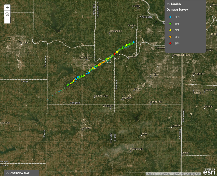
Today, May 28th, is the 1 year anniversary of this…
I think many remember this well. It was the 1st time we had a major tornado come into the Metro area for about 15+ years…since the 2003 North KC tornado. This tornado was a one mile wide beast…and there has been some interesting data concerning it and the way it developed.
This web site shows the data nicely.
What’s fascinating is the fact there there were actually two tornadoes happening that merged and then became the beast that would move south of Lawrence and then towards the western ooutskirts of Linwood.
This part of the link above is fascinating…
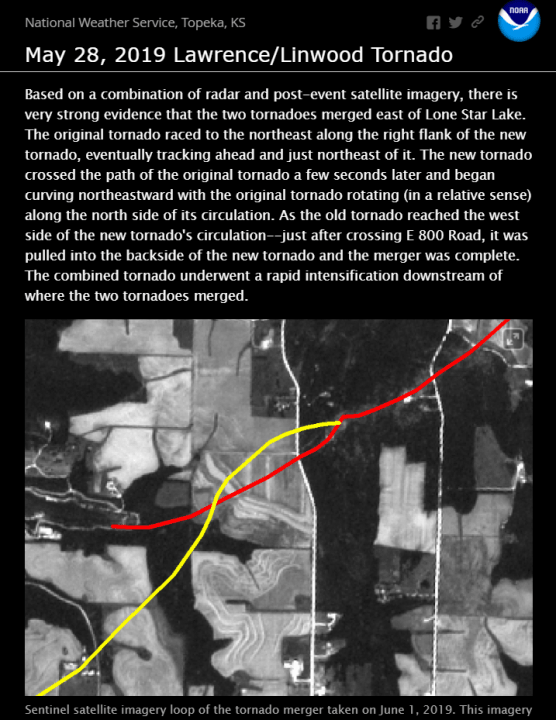
When tornadoes merge then often become much larger and more dangerous…and that’s what happened here.
There are not that many “great” videos of this tornado because it was so wrapped within a large area of rain…which made chasing it tough for sure.
I do remember that FlatlandersTV ono FB has a good perspective.
I’m happy that so far this season things have been “off” regarding severe weather here, and through MO/KS so far.
Remember tornado warnings don’t necessarily mean actual touchdowns…so far KS has reported about 11 tornados…most clustered in SW KS.

Nationwide this month…112 reports which will be whittled down in the end after taking out the duplicate reports and after so many tornadoes in April…the brakes have been put on the number of tornadoes.
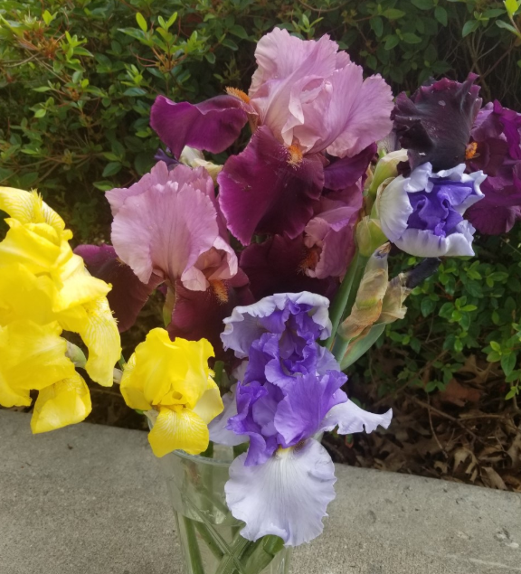
Our feature photo is of some flowers which are definitely enjoying some of the rain today…from kcpenne via email.
Joe