Good morning…and what a fantastic morning it is out there. Dew points started dropping last night and the breeze this morning is wonderful. As far as the heat goes…well yesterday was the 9th day this month with highs 90°+. The average for the entire month is around 8. So we’re well on our way and it appears to me that we’ll add more to those numbers even later next week.
There should be a bit of a break in the heat, but the dew points will increasing I think going into the weekend..so while the temperatures may be 5°+ cooler…the dew points may sort of compensate a bit for the break in the temperatures. Remember the higher the dew point the more uncomfortable it will feel during the spring and summer months.
The 1st day of summer is Saturday and that could be a day the the rain chances are the highest in the area over the weekend.
______________________________________________________________
Forecast:
Today: Sunny and hot with highs near 90°.
Tonight: Fair and pleasant with lows near 70°
Tomorrow: Mostly sunny and hot with highs in the lower 90s
Friday: Scattered showers/storms possible with more clouds and highs near 85°
_______________________________________________________________
Discussion:
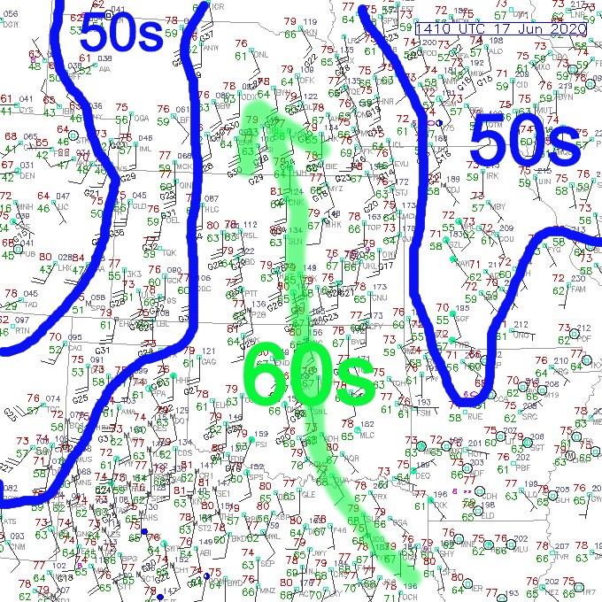
Let’s start with the 9AM surface map showing the drier air coming in the southeast to some extent. Dew points in much of MO are in the 50s this morning and that is pretty good for the middle of June. I’ve contoured in the dew points for you…the stream of 60s dew points will again expand through the region today thanks to south winds.
So while it will be another day with highs above average…so what else is new…it won’t be overly muggy today by June standards at least.
Tomorrow will be hot and a bit more humid…ahead of a weak cold front that will be northwest of the region. This means that storms will be developing in the Plains later tomorrow and the debris cloud cover from the storms may start blocking out the June sunshine on Friday.
That means that highs should back off…but with the front NW of the area on Friday that means the rain may be struggling to get to us for awhile on Friday. I’m not convinced that we’re going to get a lot of rain on Friday at this point. At least the chance will be there though…as the front will be lurking NW of here…and we’ll be in southwest flow aloft that may allow some sort of disturbance to come up and move through. hopefully in itself creating some areas of rain at some point in the afternoon on Friday.
A much stronger wave comes across the Plains on Saturday and that should set the stage for more rain and perhaps more widespread rain to start Summer off here. we’ll need it because you can tell that the grass is wanting a good drink of water right about now.
At least on Thursday late night into Friday it appears the heavier rains may be more towards the NW of the KC Metro area…some 1-2″+ rains are possible in NE KS and perhaps NW MO depending on how the convection comes together.
As I mentioned though all of these chances, if nothing else, should result in cloud cover and that will help to stop the run of 90s that we’ve seen for most of the month.
Saturday may be an off and on rainy day in the area…and then Sunday, while not perfectly dry for all during the day, may be more of the mostly dry type weather with some scattered showers/storms around. The wave front Saturday moves away so we should have some sinking air behind it. Yet we’ll warm up to some extent and it won’t take much to trigger other small areas of rain later in the day or Sunday night.
Then the heat tries to come back up into the area BUT we’ll be in NW flow or WNW flow aloft and prone to disturbances coming through the Rockies and moving into the Plains…that could be a recipe for storm chances for a few days next week. So we’ll see IF the heat can come back or if it gets shunted back to the south again because of these disturbances…the EURO seems more intent on bringing the hotter air into the area
Model data for the rest of the month is in the 2-5″ range for moisture through the area…we’ll see how that comes together. It doesn’t take a lot to look at the pattern though and think the back half of June will be wetter than the 1st two weeks.
I’m thinking of another climate related blog tomorrow morning.
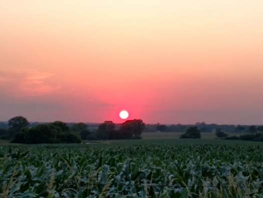
Our feature photo comes from Brad Arnold out in Drexel, MO…we got to enjoy a spectacular sunset last night.
Joe