KANSAS CITY, Mo. — Friday officially kicked off meteorological spring, but winter will dominate the weekend anyway.
The FOX4 weather team expects significant snow accumulations, especially for the metro and points south.
A Winter Storm Watch has been issued, beginning at 6 p.m. Saturday until 3 p.m. Sunday, for the entire Kansas City area.
That includes Atchison, Johnson, Leavenworth, Linn, Miami and Wyandotte counties in Kansas and Bates, Carroll, Cass, Chariton, Clay, Cooper, Henry, Howard, Jackson, Johnson, Lafayette, Pettis, Platte, Randolph, Ray and Saline counties in Missouri.
FOX4 meteorologists say light snow and flurries could start as early as 9 p.m. Saturday but will get heavy at times from midnight into mid-morning on Sunday. The snow should wind down after lunch.
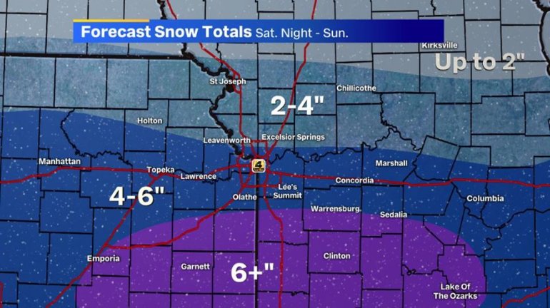
Those in northern Missouri will likely pick up 2 inches or less with this system. Those north of the Missouri River but south of 36 Highway are expected to get 2-4 inches of accumulation.
South of the river, residents should expect about 4-6 inches of snowfall. Those south of the metro could see slightly higher totals.
FOX4’s weather team says this will be a light, fluffy snowfall that adds up quickly. Travel will be impacted overnight and Sunday morning.
And once the snow moves out, this system isn’t quite done with us. Bitterly cold air will move in behind the system.
Temperatures will drop into single digits by Sunday evening, and dangerous wind chills are expected Monday morning. Actual air temperatures will fall below zero with wind chills between -10 and -20 degrees below zero.