3 p.m. Update.
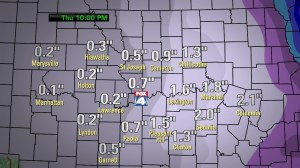
Everything continues to go according to plan as far as this change in the weather goes. Nothing really has changed in the data with our latest in-house models suggesting anywhere from a dusting to 1″ of snow. Some of the hi-res NWS models are cranking out about .07-.12″ of liquid. That would roughly correlate to 1″ of snow. There are some other factors though to consider, one being that at first, the snow will probably melt, especially considering the temperatures will be in the 30-33° range and the ground will be “warm” after a day in the 40s, as will the roads. So some of that total will go to that. The “window” for snowfall is not particularly large either. We’re thinking maybe 3-6 hours for the “decent” snow to fall. Then you have the wind factor as well. We’re seeing winds now starting to gust to close to 30 MPH, and there are winds gusting to near 40+ up across NE as I type. These stronger winds will continue to overspread the area this evening through the overnight. That will make measuring the snow, almost impossible.
My feelings about the real issue, from a road standpoint are just as valid, if not more now, than when I first put them out last night. My big concern is that there will be initial melting of the falling snow, this will get the pavement wet, then as temperatures continue to fall overnight into the teens, and as the road temperatures drop toward or before midnight, ice will develop on the untreated roads. Then with another 1-2 hours of snow on top, covering any potential black ice, all sorts of issues may develop. Again the amount of pre-treating may go a a long way to helping out the cause overnight.
So in terms of accumulations, we’ll be running with a dusting to 1″ for most of the KC area. Farther towards the east of here, namely Marshall to Sedalia to Chillicothe, amounts may end up in the 1-2″ range.
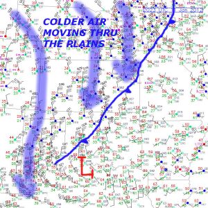
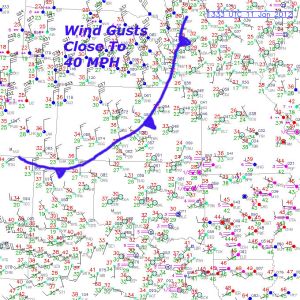
Here is the 2 p.m. surface map showing the front moving through. Areas E/SE of KC, where there actually may be some additional snowfall amounts as mentioned above, are approaching 60°.
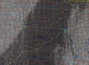
Check out the visible satellite picture…very cool showing the wall of lower clouds moving through the region as I type. Click on that image to make it larger.
While the snow amounts here should be pretty paltry, areas up towards the Lakes will get it worse, including more snow and longer duration winds. It may look like a blizzard towards the Chicago area where 4-8″+ are possible, and again the winds up there will be in the 30-40+ MPH range for most of this tomorrow. A lot of airports up there are not going to do well, and with all the blowing and drifting there may be a lot of travel issues tomorrow across the country.
That’s all for now. I’ll give you another update this evening.
+++++++++++++++++++++++++++++++++++++++++++++
10AM Update with the latest Microcast…
It seems that we’re still looking at the 1/2″-1 1/2″ range of snow through the area…perhaps lighter up towards the NW and W of the metro.
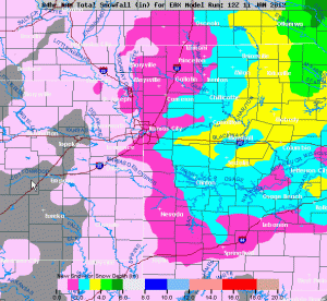
Here is the latest NAM model forecast…again very similar and a reduction from last night, especially on the MO side. Odds are for the Noon show I’ll be keeping Karli’s thoughts. Again our major concern is the melting>freezing potential later this evening into tomorrow AM…
Another update @ 3PM…
++++++++++++++++++++++++++++++++++++++++++++++++++++++++
Well our reality check is on the doorstep in the form of a cold front that will be moving through the area near lunch time…this will take the mild weather of the last couple of days and push it away, replacing it with seasonably cold air and a lot of wind.
Here is the cold front as of 7AM…moving through NE and heading this way…
 Initially early this afternoon there will be a wind shift towards the NW, then within about ab hour you’ll notice the winds really start to pick up from the NW at 30-40 MPH. Temperatures which may reach close to 50° will start falling and by the end of the evening rush will be approaching 32°.
As this is occurring a band of snow will be moving this way from the west and northwest. It will likely be expanding somewhat and as it approaches the metro from the KS side it may intensify a bit as well. The timing of the onset of snow will likely be closer to 7-9PM, after the evening rush and the snow may continue, mostly light with an occasional burst through daybreak tomorrow AM.
While the amounts of snow in the metro will be “light” by winter standards, considering what we’ve seen this year, this is looking like the biggest “event” of the season so far. At this point my thoughts from the late night update to the blog are still somewhat valid, accumulations for the metro being in the 1″ range with some upside potential IF the snow keeps going longer than I think…highest potential I think is about 2″. There is some potential for 1-3 inches towards the NE/E of KC. It will be very difficult to accurately measure the snow though with all the blowing and drifting going on.
My biggest concern is with road temperatures initially very warm, the snow will melt at first on the roads especially. Then as temperatures tank overnight that wetness will freeze up, especially on untreated roads and then become lightly covered in snow. This may create big issues overnight for traveling and is something that you need to be aware of and think about planning for not only for tonight but also for tomorrow AM. I wrote about it yesterday as a possibility and I think those chances are increasing with the potential of additional snowfall.
This will be a deal where the road crews may be able to go a long way to helping the cause by being proactive with road pretreatment later today should things continue to develop later this afternoon.
I will post some additional maps including the newest runs of Microcast by 10AM or so.
We all knew it had to end, and the good news is that the end is more like an intermission as we should moderate again later in the weekend and warm up again on Monday.
Joe
Joe
