I desperately try not to be to repetitious on the blog from one day to another, and I have to say that gets awfully tough sometimes during the summer months when the weather is essentially the same from one day to another with quiet weather across most of the country — usually it’s just hot. This past summer was different because of the various records and streaks that were alive because of the extreme heat for the Southern Plains states.
It’s not often during the winter that I sort of run out of things to blog about the weather…but I sort of feel like I’ve been going over the same things for the last few weeks. We’ve talked about the next cold front due in Wednesday, which will really be a typical January cold front in a month, and for that matter winter, that has been atypical for cold fronts around these parts.
This cold air mass should last a few days before moderating and moving off to the east of here, allowing temperatures to slowly, or perhaps quickly, depending on the model of the day’s forecast, moderate. Again, while “impressive” for where we’ve been this winter in terms of cooldowns, this coming front will not exactly be a bank buster when it comes to the heating the house. That furnace will run harder than it has been…but compared to the last couple of winters it will be a walk in the park. One thing to remember is the winds with the arrival of the cold air will be increasing as WED rolls along, perhaps gusting to near 30 MPH, so the wind chill Thursday will likely be near 0.
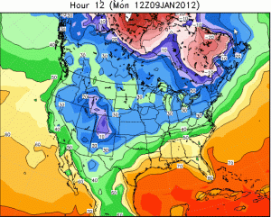
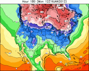
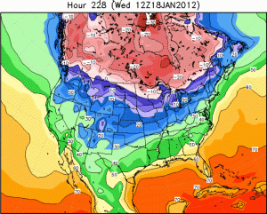
What about longer range? This is where things have been rather confusing to figure out. I still feel that the cold air will be a huge factor in the forecast, and there continues to be real potential for some VERY cold air to spill our way. Goodness knows it’s not going to be far away. So I though this AM we’d focus on just how close the cold air will be…to do that I’m going to show you 3 model maps from last nights EURO run showing forecasted temperatures across southern Canada…
Map #1 shows the temperatures at 6 a.m. Kansas City time, roughly the lows expected, click on each map in make it more readable. All temperatures are in degrees F.
 Map #2 shows the same thing…except for next MON AM (16th)
 Finally map #3 shows the same thing for next WED AM (18th)
 So what can we take from these maps? The main thing is that near and just north of the US/Canada border, it’s finally going to get cold, and stay cold for a while. Those temperatures aren’t record breakers, but they are bone-chilling. So the real cold air (finally real winter cold) may just going to be sitting there…waiting…assuming the model is close to correct.
Every so often a disturbance will come through, tugging some of that cold air our way…should a real storm form, and I wonder how one can not form given the impressive temperature gradient from north to south and the season we are in, then that more mature and powerful future storm would allow the Arctic air to rush into it and that REAL cold air would move into the region. It’s just sitting there waiting for something to force it south.
The thing is, at this point, and this changes on an almost daily basis, the flow aloft through the USA is forecast to be “zonal” or essentially west to east, with few organized or strong upper level disturbances, to help stir and create a surface storm system to allow that cold air to rush southwards. It’s frankly bizarre for mid January at least according to the EURO model. Whether or not that actually comes to fruition (a lack of disturbances) remains to be seen but that cold air will be there…and it will want to rush or ooze southwards with time. it should be noted that the GFS model handles things differently in about 10 days. It keeps SW Canada in a Pacific flow of air and allows repeated cold air shots to move through the Lakes and the NE part of the country (hello Lake Effect). For us we’d get nothing but glancing blows, followed by better than decent warm-ups, sort of like what we’ve seen all season long.
Finally this AM…of course it makes total sense for W TX to get another big snowstorm (not)…Midland, TX has had 8.9″ of snow this season. They’re 5″ away from tying the all-time snow record there. Here is the forecast from the NWS in W TX…

They will have transition issues between the rain/snow…and there is some pretty good bust potential with this storm for them, so let’s see what happens down there as the day goes along.
Have a great Monday!
Joe


