Good afternoon. Goodland KS is @ 85° as I start this blog…that’s the warmest temperature ever for the month of February. Denver, CO is at 76° and is 1° away from tying their all time high in February. Here in KC…we’re in the 60s now…no records for us locally today (75° for the date and 83° for the month of February) and aside from the winds…it’s a great day out there. There are lots of cirrostratus clouds filtering out the sunshine…but we’ll take it for sure!
Forecast:
Tonight: Fair skies and mild…50s this evening and eventually mid 40s by daybreak. The winds will be dropping off.
Saturday: Odds are NOT as nice as today. Cloudy skies with the potential of some pockets of mist from KC northwards. Highs will only be in the 50s to perhaps near 60° or so. There may be some thin spots in the clouds later in the afternoon. Areas south of KC will be warmer (near 70°).
Sunday: Not that bad really…mixed clouds and sun…temperatures well in the 40s. Average is the lower 40s for highs…we should be above that every day for the next 10 days I think!
Discussion:
I blogged extensively about the coming weather tomorrow in yesterday’s edition. Really there are no changes needed to that…it won’t be as nice or bright on Saturday and it should be a cooler too…so don’t let that surprise you please.
I won’t bother to rehash all of it again.
So on this warm day…and after the NE part of the country saw a pretty impressive blizzard yesterday with over 12″ of snow in many areas
Snowfall analysis from yesterday's storm. Data for the 48-hr period 7 am Wednesday to 7 am this morning. pic.twitter.com/xnURUIY5xb
— NWS Eastern Region (@NWSEastern) February 10, 2017
…let’s talk KC snow.
I saw some information from the folks at Climate Central about a slow(!) decrease int eh amount of snow we’ve seen since 1970 (on average). What is interesting about our snow seasons is that they can vary tremendously…
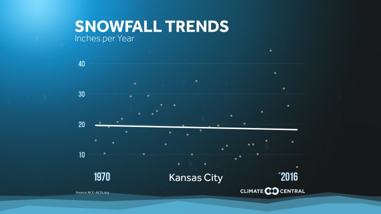
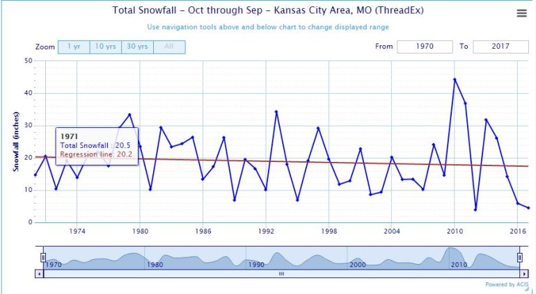
There has been a minor decrease (about 1″) in the average snow locally in the last 45 years. Here is another graph showing the extremes a bit better.

Here is another way of looking at the data above…which in the above chart is in a calendar year…now let’s look at the typical snow season…
Going back to 3/1/15 through today we’ve had about 10″ of snow…that’s not a lot.
There are really no signs of anything important, snow-wise in the next 10+ days. 1st we’re even struggling to get moisture locally. Check out the rankings over the past 90 days…
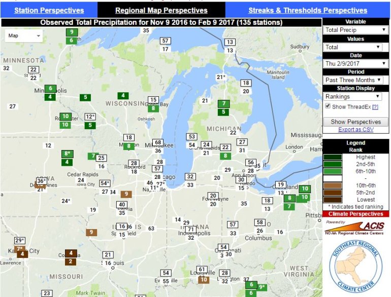
So the struggle right now for moisture is real…and the snow drought continues with no real end in sight.
There may be a storm towards the 21st or so…that will be coming into warm air ahead of it in the Plains it appears…with no cold air to work with…odds favor a mostly rain event…IF it even happens.
As a matter of fact…let’s take a look at the 850 mb level…about 5,000 feet up on the EURO model for day 10…the 20th. Let’s look for cold air masses.
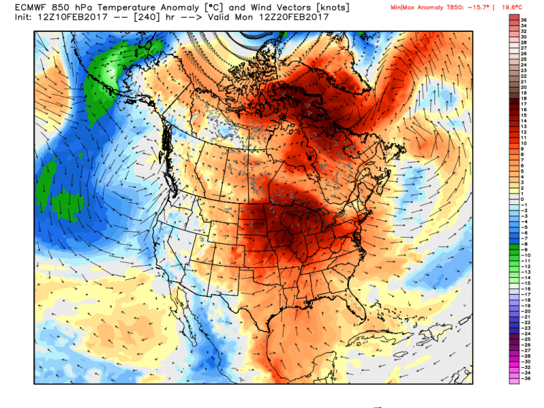
Good luck with that look snow lovers.
I’ll update you again on Sunday…no blog on Saturday since I’ll be helping out with the Idiot’s Golf Open for the benefit of KC Hospice and Palliative Care. Feel free to come out and play 9 holes…go to their website because it’s not a typical “golf” tournament!
Our feature photo comes from Tim Stout in Leawood this morning…nice sunrise!

Joe


