Good afternoon…flakes have been flying and accumulating in parts of the viewing area towards the north and northeast of the KC metro this morning. Some areas are already reported slick conditions so for those areas affected please take it slow and easy for the rest of the afternoon. Meanwhile for additional updates as this evolves please follow me on twitter @fox4wx for additional brief updates today. There may be another blog update later on this afternoon or early this evening.
Forecast: (3:30 Update)
Tonight: Very light snow ends towards 8PM or so. Final accumulations should be in the 1″ range for the KC area. Temperatures hold pretty steady in the teens. This is NOT going to be a significant snow storm for KC. Some may even get less than that. The icing was the issue…and it was only about 1/100-2/100″ but that was all it took to make things a mess.
Wednesday: Variable clouds and chilly with highs in the 20s
Discussion:
Not a lot has changed in my view concerning the evolution of the snow system moving through the area. The 1st band started a few hours ago and created about 1″ (maybe a bit more) of snow towards the NE of Downtown KC. Here is a look at the radar from the NWS in Pleasant Hill.
(6:15 Update)
The freezing drizzle took a bit longer to transition over to very light snow. As a result things became a skating rink out there, even on the treated roads. The snow aspect of this system will be minor and KC metro amounts may be closer to 1″ for most areas from KC southwards. There is better snow falling north of KC as I type this. The back side of the system that you can see as I type this out towards Topeka will zip through the area early this evening…once it passes through that will do it for the snow accumulations. The darker blues and greens are the better snowfall rates.
Overall another frustrating snow event or lack thereof for the KC Metro…icing is the worst.
+++++++++++++++++++++++++++++++++++++++++
As I type this…there is a developing area of snow towards the south of KC…there might be a little freezing drizzle involved in that as well. There is still some low level dry air out there that needs to be saturated from KC southwards however before we start getting in the game.
The data today really doesn’t change what I’ve been thinking about the evolution of things. This will be an afternoon through 8-9 PM system and it’s impacts will mostly be snow falling during the evening rush. Amounts are NOT going to be overly impressive in a “snowstorm” world but again like I mentioned yesterday we continue to be nickle and dimed with these systems. I see no reason why we shouldn’t make a run towards around .5-1″ of snow for most of the metro with some parts of the metro getting 1.5″ of snow. The highest totals should be where the snow has been falling this morning already…north and northeast of KC where amounts may be 3+” in spots. Areas west of KC proper will see at best a dusting to maybe 1″…Lawrence westwards I think.
From a model data standpoint…really it’s a matter of watching radar at this point and now casting from here…but for giggles take a look at the “experimental” HRRR model run that goes out through 15 hours. This experimental run is not widely available at this point…and it will replace the current model somewhere down the road…but I think it sort of has an idea on the snowfall totals.
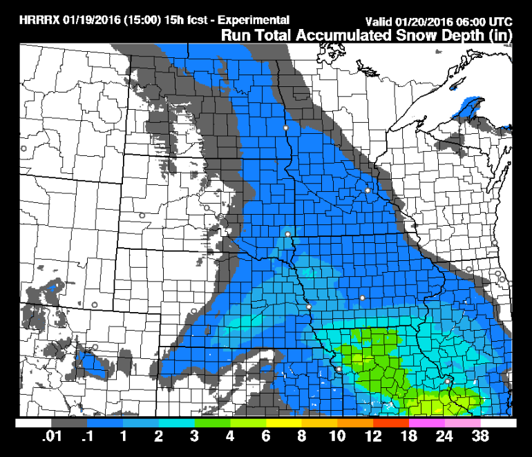
The takeaway is that the heavier snows accumulations are NE/E of KC. 3″ may be a push though for Johnson/Pettis Co MO.
The current version of the HRRR model has this…
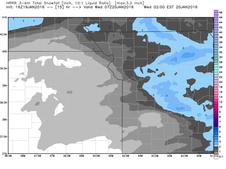
I still think some of the metro can get about ..05-.15″ of liquid out of this in spots of KC…translating to shy of 2″ “upside” snow potential in the KC metro. With that said it I don’t think that potential is overly high for any one place…meaning I wouldn’t be shocked if it turns into a glorified dusting for parts of the metro.
Again this is not going to be a big snowstorm. The concern is how this plays out for the evening rush hour and the road conditions…plus the freezing drizzle component potential at the initial stage.
You may hear about how the freezing drizzle is cutting into the snow totals. This to me is incorrect. IF we had 6 hours of freezing drizzle…that would about to what…2/100″ of liquid…converting to snow…what about .2″? How is that making a significant dent in the TOTAL snow potential. It just means that there is not enough moisture in the cloud layer where the snowflakes form. It means the storm is/was dysfunctional and wouldn’t have the ability of creating significant snow accums to begin with. The freezing drizzle (in this situation) is a symptom of a storm that is not going to produce a lot of snow.
For more details on this check in with Mike tonight. again by 9/10PM this will be winding down.
Let’s move on to another storm that needs tracking and this will be the system that turns into the big storm back east with potentially a cropping blizzard taking shape back there. There is also an interesting question about where the rain snow line sets up in the NE part of the country and where the heaviest snow totals actually sets up. There is potential for 1-2 FEET+ of snow in parts of the NE and Mid-Atlantic. Also there are going to be strong onshore winds timed out to high tide AND a full moon this weekend. That means that there could be enhanced coastal flooding of the shoreline. There are still questions how far north the worst of the storm will be…it appears though the the Mid-Atlantic region is in the bulls-eye right now.
For us this system will be developing towards the east of KC. We may get in though on the developing stages with some additional snow possible Thursday. At this point it might be something along the lines of a dusting to 1″ type of event in the area especially from KC southwards. Again another nickle and dime event here and I wouldn’t be shocked IF it goes a bit farther south of us in the end.
Depending on how this all plays out over the next few days…the less snow on the ground, the higher the chance of a somewhat milder day on Saturday…the same day the east coast should be dealing with the Blizzard.
OK that’s it for today we’ll keep an eye on the radar and you keep an eye on the roads this afternoon/evening
Joe