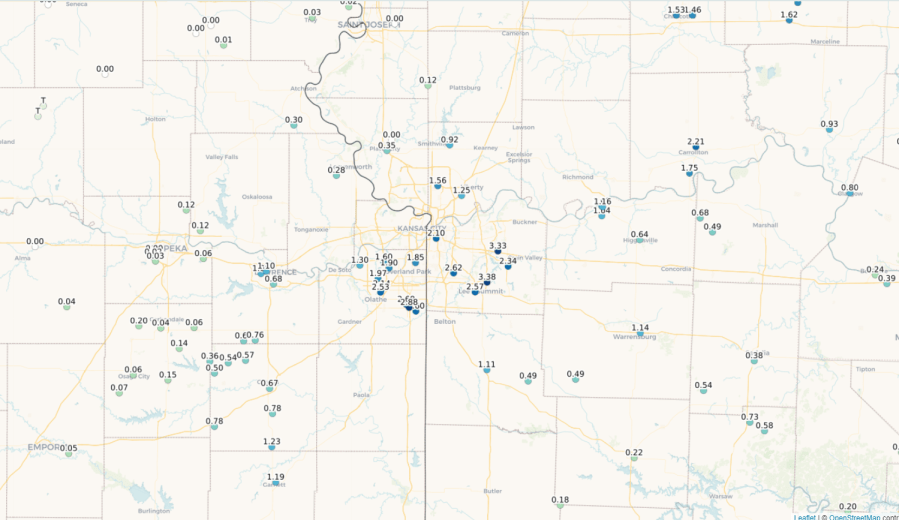
Another weird weather day yesterday with a ton of rain for parts of the area and very little (comparatively) in other parts. When things are looked at again in 2 years or whatever…and we go into the record books to look back at this day…we’ll look at the “official” stats, kept up at KCI and see that yesterday we had a whooping .25″. Some places got 20 times that much…perhaps even more.
There was also the wind damage that hit parts of west Olathe. At first I thought it was a microburst but it might have been a small and brief little spin-up that lasted a block or two. Those would be the types of spin-ups that really can’t be warned on ahead of time…just one of those things.
_____________________________________________________________
Forecast:
Today: Sunny and perfect with highs in the upper 70s with a nice breeze and lower dew points
Tonight: Clear and cool with lows in the lower to mid 50s
Tomorrow: Sunny skies in the morning with some increasing clouds in the afternoon. There may be some showers later in the afternoon or in the evening but it appears as if the better chances are across northern MO. Highs in the mid 70s
Sunday: A small chance of some additional showers/storms in the morning then partly cloudy and mild with highs 75-80°
______________________________________________________________
Discussion:
Let’s start with the rain from yesterday. Yup…believe it or not KCI had less than 1/4″ yesterday…only .13″…incredible isn’t it. That’s what will go down in the books and be looked at down the road.
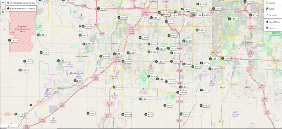
Meanwhile for almost everyone else…these are the two day rains…most of which occurred yesterday.
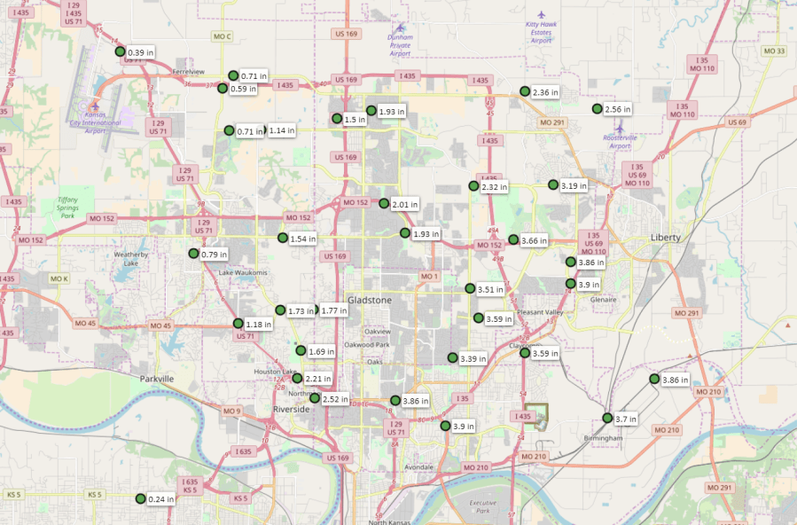
Down south…
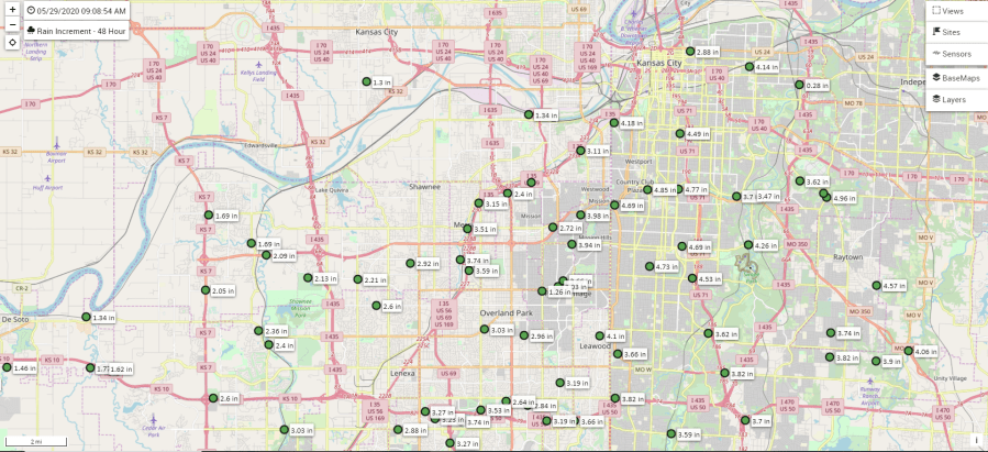
and farther south…
Here are some other totals…
Some have asked me about the lack of data outside the top two maps…that is a function of a lack of rain gauges…wish I could do something about that but I can’t and thanks to all who have filled in my information with their reports including almost 7.5″ in some area in Jackson County.
Doppler estimates were undershooting reality on this event. I even tried to dig into some more detailed data and was having a tough time coming up with reliable indicators. So the automated/manual rain gauges out performed the fancier technology once again.
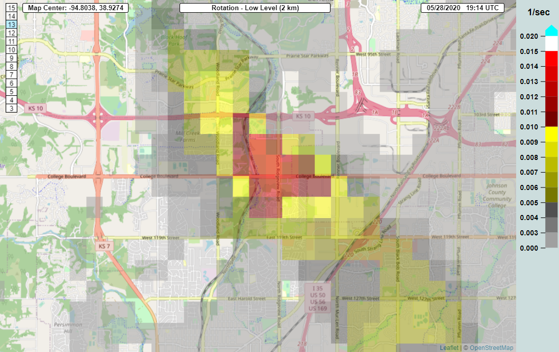
As far as the potential brief EF0 tornado in West Olathe…that remains to be seen, and odds are it won’t be looked into any harder because of the minimal damage to a few shingles and a tree snapped, but if it wasn’t a tornado then it appears to have been a “wet” microburst if nothing else.
What causes a Microburst? (from the NWS)
“It all starts with the development of a thunderstorm and the water droplets/hailstones being suspended within the updraft. Sometimes an updraft is so strong it suspends large amounts of these droplets and hailstones in the upper portions of the thunderstorm. There are many factors that can lead to evaporational cooling (sinking air) and therefore weakening of the updraft. Once this occurs, it is no longer capable of holding the large core of rain/hail up in the thunderstorm. As a result, the core plummets to the ground. As it hits the ground it spreads out in all directions. The location in which the microburst first hits the ground experiences the highest winds and greatest damage.”
There was some rotational indicators though in the spot of the damage…so it’s possible there was a brief spin-up.
then a couple of minutes later…
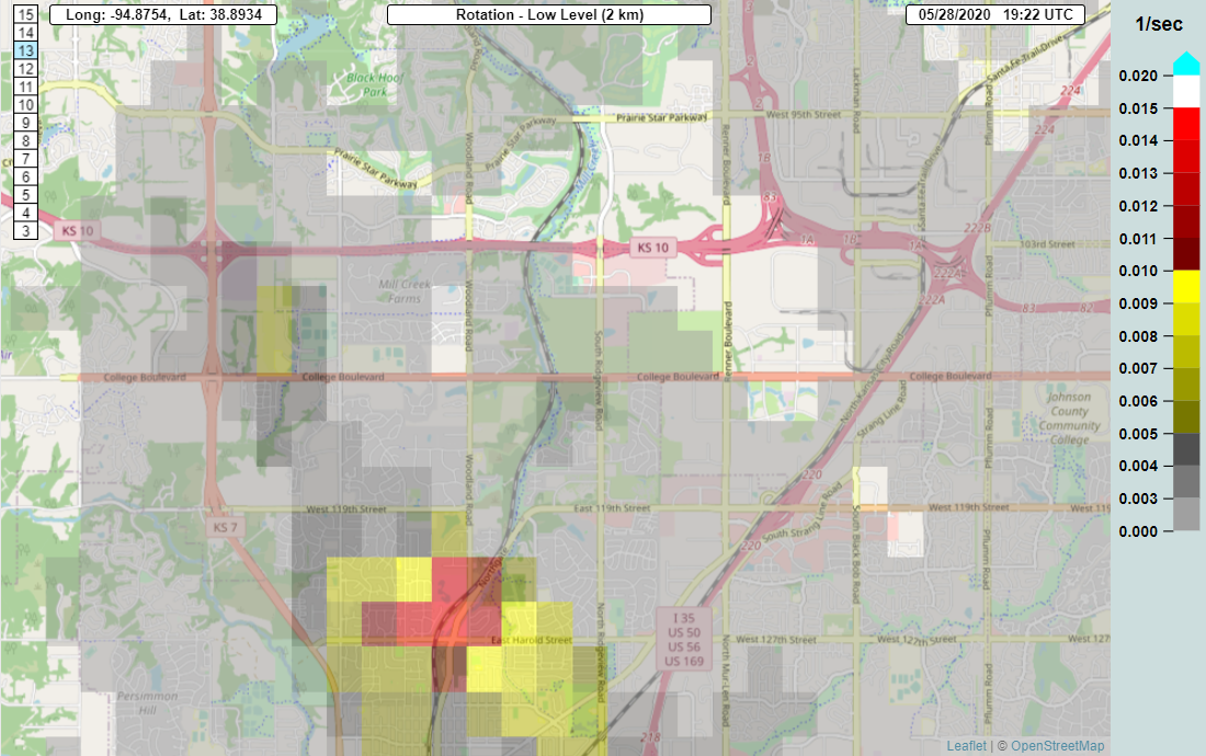
Whatever it was was fast hitting.
Moving on towards the weekend…
We’ll be in pretty good shape but there is one or two flies in the ointment. There will be a tendency for little disturbances to come down from Nebraska moving towards the SE. One will come later tomorrow and while that will increase the clouds…the better rain chances appear to be more focused toward northern MO as opposed to the KC Metro and points south area.
The NAM has been the most bullish on this…and here is the morning solution…keeping the rains up north of KC.
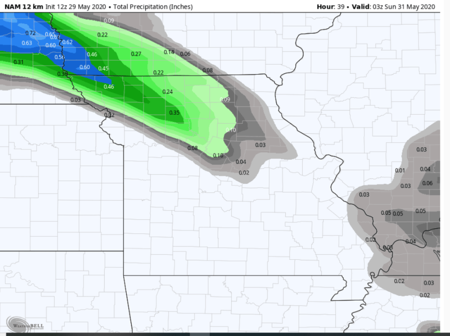
It’s close though..so it’s still worth a mention of a chance…the model is also really generating quite the cold pool of air with this…perhaps too cool I think. It keeps highs in the mid 60s tomorrow. I think we should get enough sunshine during the day before whatever weak front moves in from the precip up north to get us into the 70-75° range…perhaps falling a few degrees later in the afternoon.
Then on Sunday whatever weak boundary that the later Saturday activity pushes through…will be around…the winds above the surface will be blowing over that boundary…it’s not a great set-up though and as a result any activity looks to be somewhat scattered during the morning. Overall it looks like a pretty decent weekend. Not perfect…pretty good though.
We may have a few more showers/storms around on Monday…with a lot more wind out there too. That means we’ll warm up nicely into the 80s…and then it gets hotter and muggier during the week. We’ll make a run towards 90° either Tuesday or Wednesday with iffy storm chances on Wednesday.
It’s a warm to hot outlook in the latest 6-10 day forecast…

and if we want to go into next weekend…

So a nice shot of summer coming…to start the 1st week of June, if not a bit longer. There is a LOT of moisture in the ground as well and that will take quite some time to evaporate so that means a lot of humidity is coming to us next week with higher dew points…likely in the upper 60s to lower 70s.
The feature photo of the day comes from William Johnson…a had a spectacular sunset last night.

Joe