
Good morning…it’s about to get wet today for about 3-4 hours or so. radar showing storms and rain inbound from KS towards the northeast. Some brief heavy rains are possible but at this point no severe weather is expected.
The weekend as a whole won’t be terrible. Rain chances will increase to some extent on Sunday, although even there I’m not sure how much of the day will be impacted…then Monday could be a bit more iffy at times. There will be a very slow moving front that will be working through the Plains and that means persistent rain chances. Certainly not a washout…lots of time for outdoor things.
_____________________________________________________
Forecast:
Today: Rain/storms moving up from the southwest this morning and lingering till around or just after lunch. Highs will again struggle today with 70-75° potential with enough sunshine although IF we don’t get much sunshine…we may not even get to 70°
Tonight: The higher risk of storms will be north of KC. Mild with lows near 60° at daybreak
Saturday: Warmer and breezy with highs 80-85°
Sunday: A few storms are possible at some point…perhaps in the afternoon/evening. Warm and huid with highs 80-85°
Monday: Rain chances should be peaking…timing appears to be in the PM but we’ll see how that evolves. Locally heavy rains are possible too. Severe weather risk appears to be on the lower side mostly…but some hail and wind would be possible. Highs well into the 70s.
______________________________________________________
Discussion:
In a sense we need this rain and disturbance to move through the region. I say that because it will help to “re-shuffle” the atmospheric cards a bit and help to rearrange things.
It’s been a persistently gray week around these parts. Glimmers of sunshine every so often but overall very cloudy. This wave coming through will effectively shunt that moisture away from the region and things will become more seasonable starting tomorrow.
Today though…the story is the weakening rain/storms moving through. Here is radar.

and a broader look at things…

This thing may tend to hang around through 1-2PM or so…at least the rain chances will.
Then lots of clouds, thinning later in the afternoon will be the general rule. The rain that is out there has generated a rain cooled air mass that may only slowly modify this afternoon as it moves into the area with the rain itself. So highs today will again be below average it appears.
What this will do though, as mentioned is rearrange things…so tomorrow is a more typical May day. Warm…humid…a bit breezy…with small evening storm chances. You will certainly “feel” the difference.
Overall Sunday may not be terrible either…and as I’ve stressed…don’t cancel outdoor plans for Sunday…let’s just take this as it comes.
Monday is a bit more iffy though as a front slowly crawls into the Plains. It may stall nearby for the early part of the week and that means repeated rain chances with heavier rains possible…perhaps some localized flooding as well since the atmosphere will be loaded up with moisture and the rain/storms that form will be efficient producers of rain it appears.
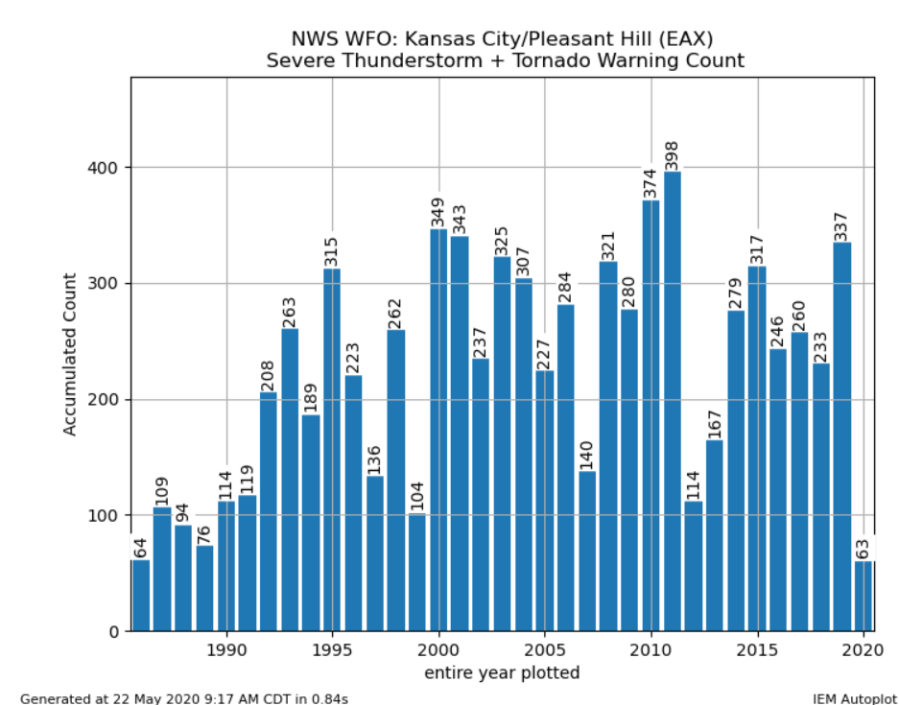
On the subject of severe weather…I’ve written and talked about the “quiet” start to the season thus far…we’ll see what comes our way in June…but from a local perspective so far 63 warnings have been issued thus far (severe thunderstorm and tornado) from the NWS is Kansas City
on the KS side…out towards Topeka…here is the running total.
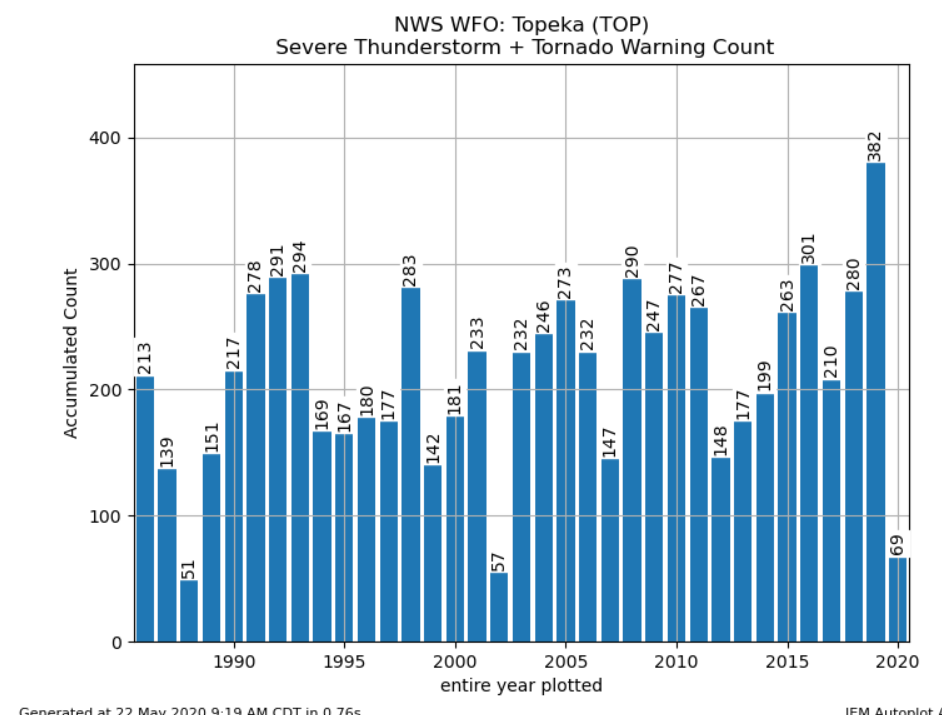
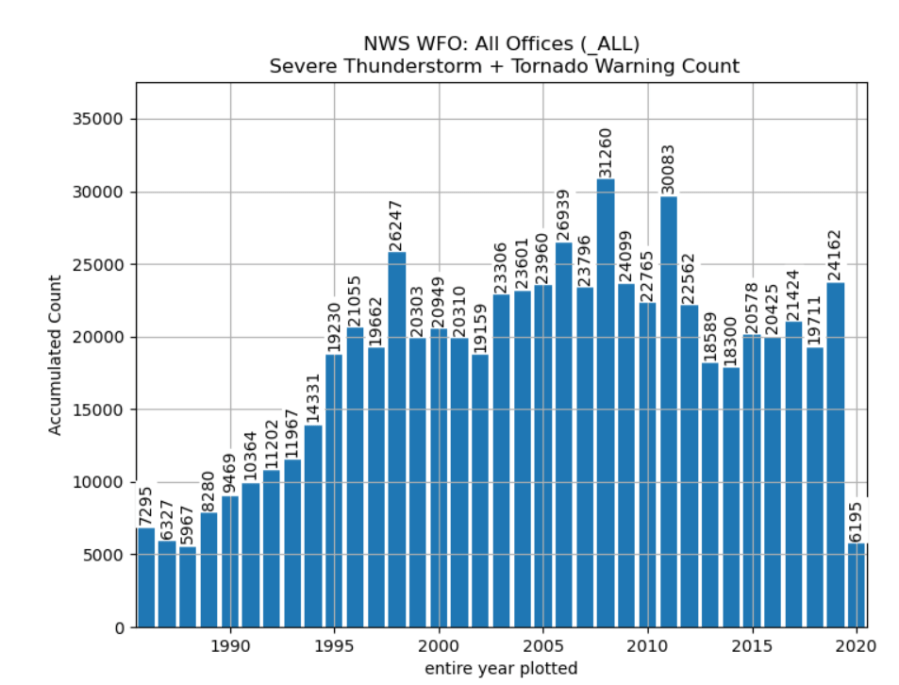
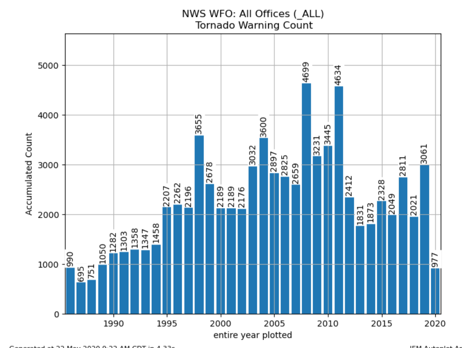
It’s important to note that the bars represent the numbers for an entire year…
IF we look at all the NWS offices…so far at least this is what we come up with.
and just looking at tornado warnings…for all offices nationwide.
Let’s hope that continues.
There were some impressive storms in western KS yesterday. All sorts of supercells including this one caught by Reed Timmer.
Neat video.
More importantly the rains were welcome in a part of the state that is in drought…
OK that’s it for today…iffy blogs for the weekend depending on the weather.
The feature photo is from Sheila Jackson…along the MO River.

Joe