Good morning…it’s really starting to feel like late spring and summer out there. I played golf yesterday and I was sweating buckets so I guess almost summer is here. Dew points were in the mid 60s which, in the scheme of things, wasn’t awful by KC standards. The dew point this morning is a bit higher and it is muggy for sure.
Highs over the weekend were in the mid 80s…which was above average but more expected in late May…so we’ve turned the corner on the real cool weather of May thus far. The month is running 3.1° below average though and it will be tough to make that up.
______________________________________________________________
Forecast:
Today: Variable clouds and mild with highs near 80°. There could be downpours and a thunderstorm just about anywhere really. The activity though will be moving from the north to the south.
Tonight: Additional storms possible, dependent on whether or not a disturbance is generated in eastern OK and comes northbound. Lows in the 60s
Tomorrow and Wednesday: Same really. Although there could be a decrease in the coverage IF that disturbance is real and we get more rain tonight. IF not the more storms/rain possible tomorrow. Highs both days well in the 70s to near 80 depending on the rain timing.
_______________________________________________________________
Discussion:
Well this is the wettest time of the year.
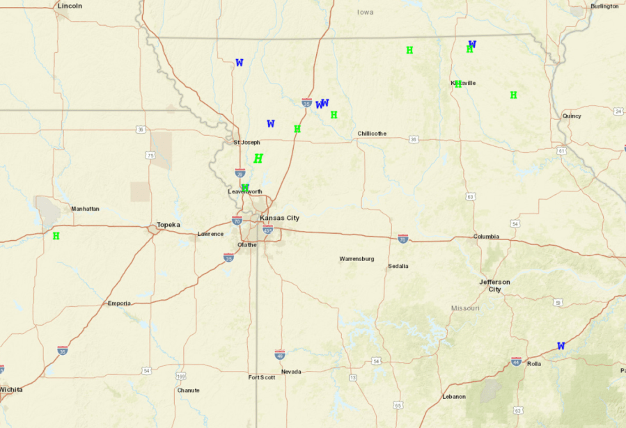
For many of you, there hasn’t been much rain at all this weekend (so far). For some…hail, gusty winds, and strong storms have affected you for an hour or two. Yesterday some strong to severe storms developed north of Downtown KC…pretty impressive storms. Here are the severe weather reports
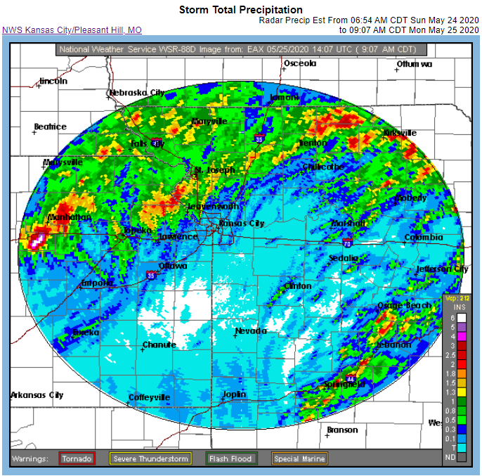
The rain was impressive in spots and very much lacking in other areas…it seems areas north of I-70 were in a more favorable region for rain. Here are the doppler indicated totals through 9AM or so this morning.
KCI has had .77″ of rain thus far this weekend.
Flash flood watches and warnings are in effect for most of the region.

Data today supports a nicer upcoming weekend.
The process though of getting to that nicer weekend is loaded with rain chances.
So let’s start with radar…

and closer in…

We’re pretty much in due south to north flow right now above us. That means what disturbances form down to the south of us will come northwards along and parallel to the State Line.
The best way to show this…is by looking at what’s happening at around 18,000 feet…below you’re looking for various red blotches…these represent areas of “vorticity”. These areas create lift on the leading edges…that lift can turn into storms/rain considering how moisture the atmosphere above us is.
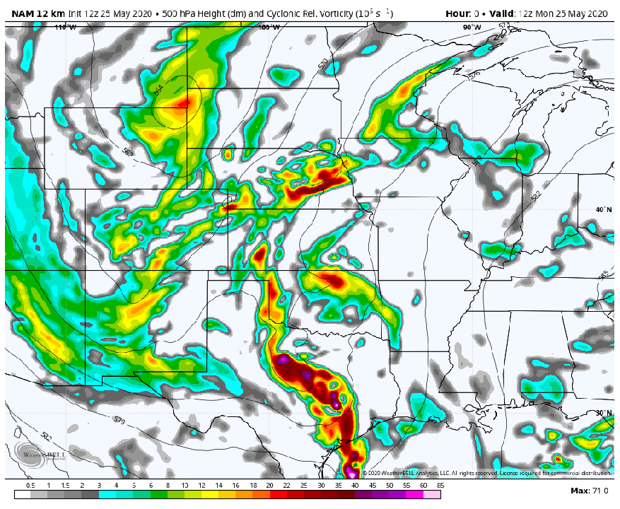
You can see how the disturbances are coming from the south to the north and interesting a whole upper level low develops. This is a good thing and bad thing. Initially on Wednesday and maybe Thursday too…these disturbances will rotate around the developing upper level low and bring rain up from the south…and even perhaps from the southeast moving towards the northwest.
In time though…perhaps later Thursday the upper level low will be moving away from the area..and that will allow drier air to start coming in from the NW and north. That is the hope for drier weather over the weekend.
As a matter of fact as that upper level storm moves away from the southern Plains later in the week a ridge will build in. That’s good news for those who don’t like severe weather risks. That really shuts diminish the prospects of widespread severe storms and that will be the case heading into the end of the month. Sure there can be some rogue things out there but it will be a quieter than average end of May from a severe weather prospect at least and potentially a drier than average end too.
Some signs as well for a warm to hot start to June too. There will be a good deal of moisture in the ground by then…and that will turn into steam heat…so the dew points will be poised to stay on the high side.
The feature photo of the day comes from Kortney Hadrick
Joe