FYI…I’ll be taking time off next week…so no blogs and very little to no social media for me…I will monitor twitter and respond if you need something. You can follow me at @fox4wx on twitter. If not…see you next Friday!
The overnight storms are getting old already. During the summer months they can be an important aspect of getting some rains in dry patterns. The problem is that they usually have strong winds and that’s what we’ve seen here these last two night. The other issue is that they are very difficult to track far ahead of time because they typically don’t come together until about 6-10 hours before they arrive. That was the case last night.
The daytime data showed the higher chances of storms across northern MO…the evolution during the 7-10PM time-frame though forced me to update the forecast and bring the storms in towards 3-4AM or so…with the potential of gusty winds. That’s what happened in the end.
The perils of forecasting things that don’t exist sometimes…until they exist.
_________________________________________________________________
Forecast:
Today: Variable clouds and muggy.. Temperatures are sort of tricky. I thought yesterday we’d pop into the lower 90s…we still may but the clouds this morning may keep us more in the 85-90° range.
Tonight: Let’s try this again. Partly cloudy and muggy with lows in the 70° range.
Tomorrow: Hot with highs well into the 80s
Sunday: Hotter with highs in the lower 90s
___________________________________________________________________
Discussion:
So why the overnight storms…
Well we’re in a pattern where clusters of storms forming in the western Plains move eastbound….then turn southeastwards. It’s not unusual for this time of the year really into the summer months.
Here is a diagram showing the set-up…
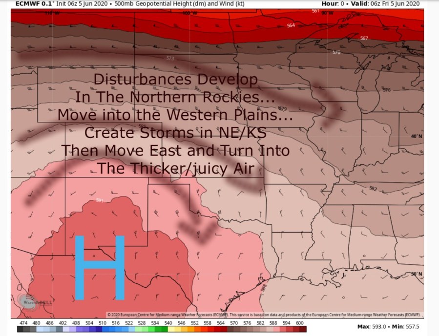
What has to change…well that ridge in western TX and northern MX needs to move eastbound and bring the more of an west to east or southwest to northeast flow of air above us into the area…that will allow these disturbances that form to remain farther north of the area.
Data suggests this will happen over the weekend. Tonight though is still a weird night and while the set-up isn’t as favorable…something can still happen overnight. I am a bit more confident though that we’ll stay dry overnight…or at least whatever develops may be more isolated and not be a whole “thing” that comes down towards the region in the wee hours of the morning.
The trade off to this is that we should get hotter. As the ridge moves towards the area…the 90s and 100s that were out there in the Plains yesterday come closer to the area. So while the dew points remain elevated the heat builds in stronger since the ridge represents a hotter air mass. So odds favor the weekend into Monday being near 90…to close to 95° in some areas, especially Sunday and Monday.
So that get’s us through Monday…
Then there is the curious case of Cristobal that is expected to move into the Gulf Of Mexico over the weekend and potentially re-organize into a tropical storm again.

It has created feet of rain in Central America these last couple of days and is really a mess of a tropical depression (winds under 39 MPH) and it’s over land…just sort of spinning around and moving in a loop de loop fashion. It’s unlikely to be even a tropical depression at this point.
With that said the waters in the Gulf Of Mexico are warm…and warmer than average so whatever is left of the storm could/should somewhat reorganize as it moves northwards.
That same ridge that will bring us the hotter weather will slide east to the area early next week…that means the tropical system down in the Gulf has a pathway to come due northwards in the the region.
Here is the way the EURO handles it…you can see the circles representing the storm move into LA then more or less around the western edge of the ridge into MO and in the end it gets absorbed into another dip in the jet stream.
How this all plays out is still a question and IF that dip in the jet stream comes out slower there would be room for the tropical moisture to push farther eastwards. We’ll see how that plays out. a farther west push would mean heavier rains in the area.
Interestingly IF that tropical moisture wasn’t coming up…we’d have a set up for severe weather with a heat breaking cold front on Tuesday because of that other dip coming this way from the Plains states.
As is the focus could be heavy rains and where that sets up. The data today and last night shows the potential of the heaviest rain towards central and eastern MO…perhaps 2-5″ worth. We wouldn’t get as much here BUT again any westward deviation to this rings heavier rain into our area.
You can see how swollen the atmosphere is with moisture by looking at this map. This is the Precipitable Water in the atmosphere and shows how much moisture is out there in a vertical column
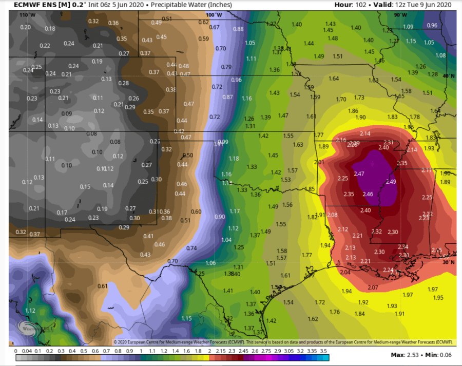
See that core down towards AR? That is the core of the storm’s moisture BUT a lot has spread into our area as well so whatever rains we get may be rather efficient producers on Tuesday. More so IF the remnants of the tropical system come farther westwards.
Our feature photo comes from Tom Hughes…pretty sunset over the MO River

Joe