So far, the winter of 2019-2020 hasn’t exactly been one to remember. There’s been a few days where we were abnormally warm and cold, but nothing like the widespread Midwest Arctic plunge in late January last year. And the same thing can be said of our snowfall. In fact, there hasn’t been any big “blockbuster”-type snowstorms for our area this winter (and I know plenty of people that want to keep it that way). We’ve only had THREE days so far this season where we picked up more than one inch of snow for the daily total.
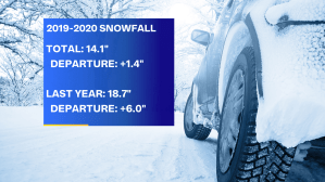
Compared to average, our numbers are actually right on target, and even just a bit on the high side. Since November, we’ve picked up just over 14″ of snow. The normal amount for this time of the year is 12.7″, so we’re not doing bad at all. And what about this time last year? Well, it was definitely more active than what we’ve been seeing so far in 2019-2020. On February 10th, 2019, the running total was 18.7″, exactly half foot above normal.
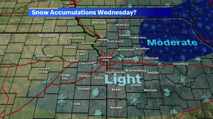
So, we’ve just been picking up wave after wave of quick dustings and 1-3″ snow events, so far, and this Wednesday could be very similar. To check out the full forecast on what’s to come midweek, check out our forecast online or head over to Joe’s Weather Blog. Early indications are pointing to another system throwing down light accumulations mainly east of I-35 with more moderate totals over Northern and Northeastern Missouri into Illinois.
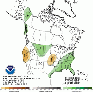
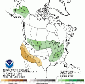
And what about the rest of winter? Is it possible that we get more intense snowstorms before the season ends? Well, according to the Climate Prediction Center, there’s some signs that the end of winter could be drier than normal at least. The early portions of spring could be a bit more up in air, which makes sense considering the wild rollercoaster of temperatures changes and rounds of precip that roll through from March to May. And of course, we’ll be watching out for the impact this winter’s snowpack around Kansas City and upriver will have on the springtime flooding, especially after a record-setting 2019.