The picture to the right shows the High Camp area @ Squaw Valley…never a good thing during this time of the year…more on that towards the bottom of the blog.
So what do I know on this Saturday afternoon….
1) High clouds are streaming through the region and will continue to do so for the rest of the day/night and part of Sunday
2) A strong(!) but not unusual cold front will move through the region on Wednesday, setting the stage for the potential of falling temperatures WED and a cold THU-FRI with the potential of single digit lows on FRI AM.
3) You can follow us on Twitter @fox4wx
That’s it!
The forecast is going to get more and more complicated from there, and even perhaps before then as well. For example as early as Tuesday, both the NAM and GFS are bringing rain into the region. This is associated with a piece of energy int he western part of the country that will be dropping into the SW part of the USA, then spinning into W Texas, and then somehow curling up through OK and affecting us during the day on TUE. The GFS has this a bit farther south but also brings a shield of rain our way. The Canadian and the EURO both keep the storm well south of here and keep us dry. I’ll be mulling that over the afternoon. My gut is to keep the forecast unchanged for Tuesday.
The thing is, IF the other models are closer (i.e. the rain is nearby and we’re locked into clouds), we may have a tough time getting to 40-45° on Tuesday. Should the other two models be right (more sun and light winds, potentially we get to near 50° or above)
Concerning the strong cold front…this the models agree on. Still not totally sure on whether once the front moves through sometime around daybreak on WED, temperatures start falling or does the really cold air lag behind the front a bit and we try t warm-up to near 40° by lunch before temperatures start to drop off. It will get windy though as the day progresses. Highs on Thursday should struggle…more than likely near or below 32° and potentially only in the 20s. The coldest highs so far this winter was on 12/4-5 with highs of 28°.
What happens from there though is a big question mark. I thought the EURO model from yesterday afternoon was pretty good with what I could envision in the 10+ days. I seemed logical to me that the cold airmass would move through and we’d moderate next weekend before turning real cold again towards the middle of the month. Today’s run now brings a re-enforcing surge of cold air next weekend, then moderates us before we wait on our next cold shot that may not arrive till I have no idea when. It get’s stuck along the US/Canadian border, which would be highly unusual for mid January.
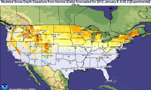
There continues to be a big issue concerning snowcover in the USA…it’s really unbelievably low. While this is good news for many, it’s bad news for those businesses that depend on the snow for money. Ski resorts amongst them. Business is way down this year compared to the past years and there are no immediate signs of improvement. Take a look at this map showing the departure from average of snowfall across the USA.
 The main focus should be the area from I-80 northwards. Pretty big departures in the Rockies and also across the upper midwest and New England. There are some shades of blue out there in the upper elevations of some of the Rockies, but mostly that’s a lot of brown showing up.
Today, compared to last year is also pretty astounding…12.5% of the country is under snow cover today with an average depth of 1.4″

Last year 42.7% was covered with an average depth of 5.3″!

You can really see the differences out west and up to the north.
In MA they’ve cancelled the sled dog races due to a lack of snowfall and as mentioned earlier some ski resorts are not doing too well and have closed down for now. While soil moisture conditions are good according to area farmers, there are growing concerns through the western plains area about a lack of precipitation.
I still see no indication of snowstorms coming this way for the foreseeable future.
Joe


