Happy Thanksgiving Eve! For those who follow the Weather Blog over the years…we always release the Winter Forecast early (it’ll be on the air tonight on FOX 4 KC at 9/10PM) as a thank you to all my readers for their support of the blog each day and through the years. Wednesday night newscasts on the eve of Thanksgiving may find you running around traveling or with friends and not actually sitting in front of the TV…so now you get to know our thoughts for the upcoming winter. Some of it is just for fun…some of it it science…the end result hopefully is something close to what will actually happen. We’ve had our hits…our misses and our “if only” times through the winters. Sometimes we get the trends right…others we don’t…that’s the nature of doing the somewhat impossible I guess. It’s tough enough forecasting a winter storm usually 24 hours ahead of time…let alone trying to pick out a number for one station (KCI) over the course of about 4 months or so. At least when we’re wrong we’re not afraid to tell you. Let’s see how things pan out this year.
I used to write hugely EPIC blogs on days like today…I think my record was something like 3000 words a few years ago. This blog won’t be like that (good for you). I’m basically just going to show you the graphics that have been created for the newscasts tonight and also add some of my personal thoughts at the end of the blog about what I’ve noticed over the last couple of months. I’ll try (gulp) to keep that part of the blog somewhat short…but you know me :).
Of note as well…I may revisit MY ideas again towards the 1st day of the winter. IF you remember last year at about this time…I was somewhat more bullish for snow…but said during the “forecast” that IF we weren’t in business by 12/15 we weren’t going to do well with snow totals in KC that winter. Well we didn’t and we didn’t. It was a paltry winter for sure. The funny thing is, I’ve been talking to many of you who seem to want more snow this winter than what we’ve seen. So with that thought hanging out there…let me get an idea of where YOU stand for this winter. I’ll try and use the results in teh next few days on FOX 4 News!
OK so without any further ado…let’s get into the forecast from the team. FOX 4 KC was the 1st station to approach Winter Weather forecasting as a team and the tradition continues again this year. I’ll post the individual forecast thoughts and ideas abut the trends for the season…then in the end I’ll put in the team average which serves as our “official” forecast for the season. The measuring point is KCI airport. Of note as well…snowfall variations around KC (like most other places) can be ridiculous most times…I’ve seen 0-12″ snows in the region from individual storms. Again picking one point in a viewing area to base a forecast off on is a bit crazy. It would be easy to say we’re forecasting 5-35″ of snow in the viewing area and in the end that type of forecast can’t miss (and in reality could happen…since the viewing area goes from the Lakes region well south of KC to the IA border) but we’re going for a point on a map really.
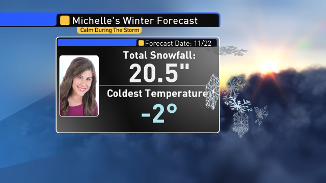
Let’s start with Michelle Bogowith.
Here are her ideas…
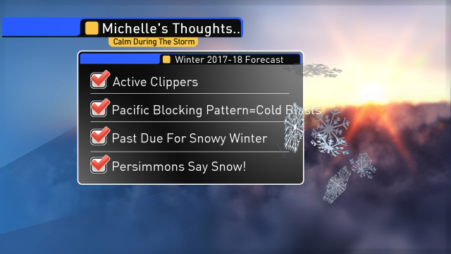
and her forecast for the winter season
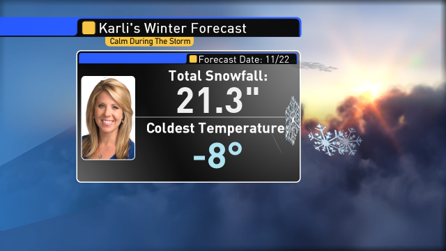
Next up is Karli…
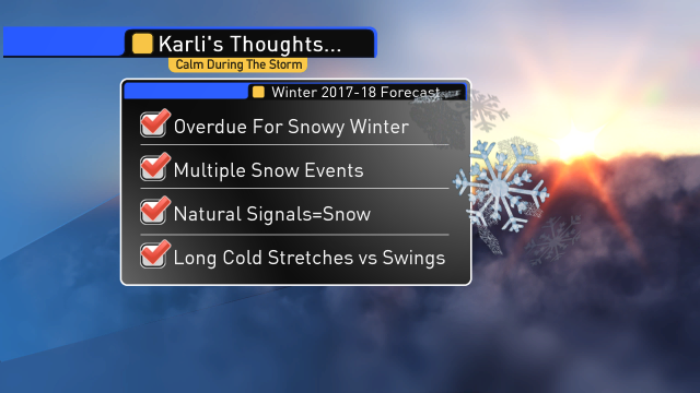
and Karli’s forecast for the winter season is…
next on the way is Chief meteorologist Mike Thompson…
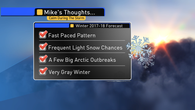
and now Mike’s forecast for the season…

and finally…last but not least…yours truly.
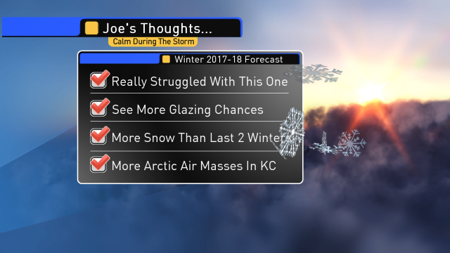
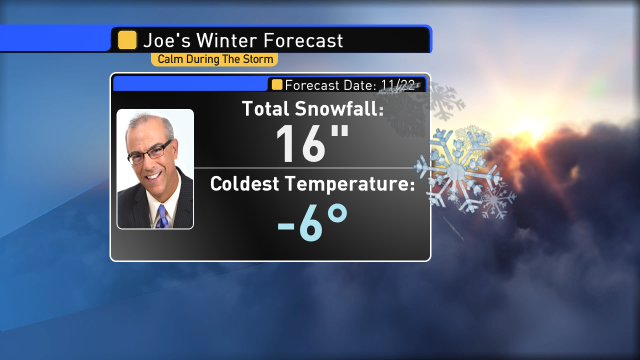
and drum roll please…answering the #1 question I get every year in November especially…”how much snow do you think we’ll get this year”?
OK we now have the individual forecasts…
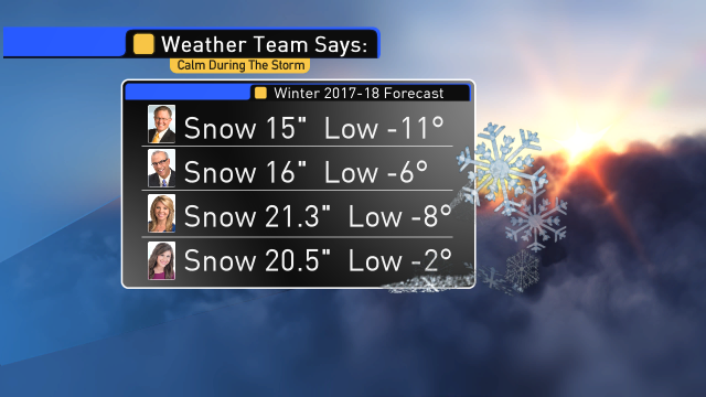
now let’s average things together and come out with our official forecast!
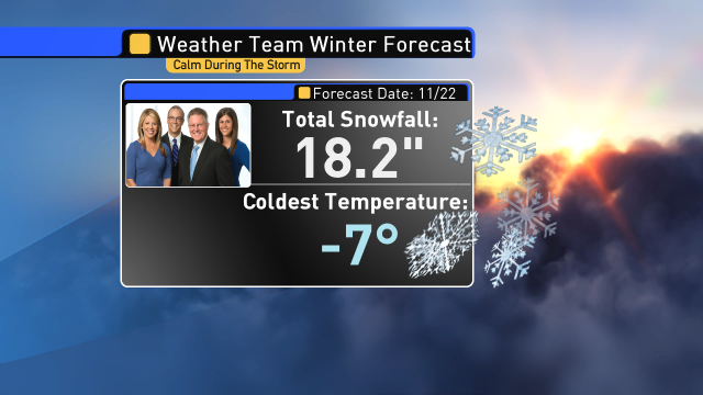
Now you know! IF you want you can stop reading right now…but if you want a somewhat deeper dive…keep on reading because you know me ;)
My overall thoughts…
Like I mentioned earlier…this will be more of a jump in the shallow end of the pool and not 2000 words worth but I wanted to give you some insight about what I’m seeing and have noticed over the last 2 months or so.
I tend to look at stats more than anything…and the one glaring number to me is what Michelle brought to my attention a while back I think…and that is that we’re NEVER had 3 years of snow totals IN A ROW with less than 10″ of snow. There is a 1st time for everything I guess…but I don’t think this is that 1st time. I hope not at least because I have a tendency to forecast higher snow totals than many…and I’ve been burned by it. With that said, I’ve started out over 10″ as a base and went from there.
Other factors…there is a La Nina in place. I’ve written about this quite a bit lately in previous blogs. We’ve shown how it could influence the weather…and at least to me, for the last 4+ weeks it’s been doing so nicely. In previous blogs I’ve written about our average snows during these events…but it’s important to note, at least in my opinion, this will be considered a weak to perhaps moderate La Nina. There are heavier snow trends in moderate events for KC. Right now we’re in “weak” status and are forecast to stay there for the rest of the winter. A bump up in “strength” does have a statistical bump up in snow in KC. Something worth monitoring. An important note…while La Nina is out there in the Equatorial Pacific Ocean unless it’s overwhelmingly strong, I’m NOT a huge believer in this one factor being the end all be all of winter weather forecasting…there are many other variables.
One of them is the amount of “blocking” that occurs in the northern latitudes. There has been a prevailing tendency in the last 4-6 weeks of a lot of blocking up there forcing colder air masses to drain southwards into the northern US and draining farther south at times. This is a characteristic of La Ninas. This one (La Nina) is more focused towards eastern South America which tends to favor more blocking and jet stream influences in the North Atlantic. This has an effect on our weather locally…as I mentioned in a blog over the past weekend I think.
These various indices (NAO, AO and others) all have some role in how things can play out in the Plains. My deep dive this past weekend when it came to significant snows in KC over the last almost 40 years shows that the NAO (North Atlantic Oscillation) has MORE of an effect on bigger snows in KC than the Arctic Oscillation value (AO) that we monitor as well. We love to see both being negative in nature though as a “heads up” about potential though. See my blog from this past Sunday for more information about these values and their importance.
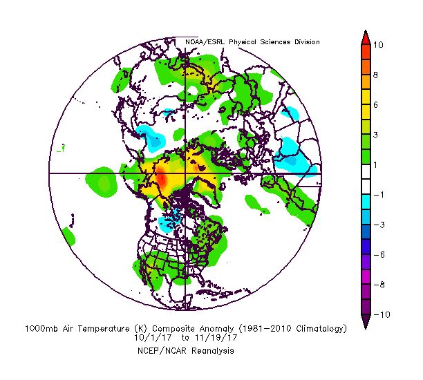
Clearly however there is a “difference” this fall compared to last fall when looking at the average temperatures in teh northern hemisphere. Last fall the colder air was always over towards Asia it seemed.
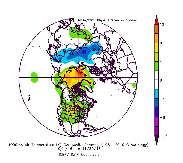
Except for a brief period in December in 2016…it seemed like this cold air would have a tough time coming to our side of the world for any real length of time…
This year there has been more noteworthy cold through parts of Canada…even at times Alaska.
and IF we just look at the last few weeks (through 11/20) it’s really more pronounced…
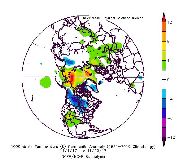
We’re running almost 3° below average this month though yesterday compared to almost 8° ABOVE average last November heading towards the winter season (and this continued for most of the winter in 2016-17).
Looking at the snow that’s on the ground NOW…there is more compared to last year at this time…slightly encouraging for winter enthusiasts I think.
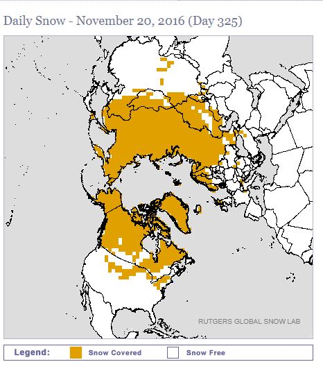
Now this year’s snow cover…
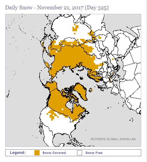
at least Southern Canada has filled in somewhat. I would like to see some more across the northern US though. This keeps the cold air masses up there cold when they come down here.
These are just a few things I look at…there are others as detailed in the blog in previous writings…of which the bigger ones to me are the persistent area of higher pressures towards Alaska and also the persistent area of higher pressure in the SW part of the US…Phoenix hasn’t had a drop of rain this season yet and they’re on the 91st straight day without moisture.
A visualization of historical dry streaks in Phoenix. The current one of 88 days is 39th longest and climbing. Longest is 160 days (1972). #azwx pic.twitter.com/SN28jAqHwm
— NWS Phoenix (@NWSPhoenix) November 20, 2017
Perhaps a connection to our drier weather this month as well…as we’ve been more in a persistent NNW/NW or WNW flow of air aloft…that type of look isn’t the greatest for “large” storms in the “big” picture. It won’t continue all winter though…so we’ll need to “make hay” when it isn’t doing that…the issue is will we have cold air around when that happens. This type of flow though could allow a few more clippers to add to our snow totals that come from the NW and dive in perfectly for fast hitting snows.
I’m also concerned about more “glazing” type of ice scenarios this winter for the area.
So when looking at ALL of that AND some other things…that’s why I’ve come up with MY 16″ total…I’ve been vacillating between 15-20″ for the last few weeks…average is 18″ so yes I’m predicting a BELOW average snow season in KC (16″) but more than what we’ve seen in the last couple of years! As far as temperatures go…yes I do think we’re going to get some pretty decent outbreaks of cold arctic air this winter…more so than that last couple of winters. With that said though…there will be more than a few times of balancing warmth…so I think overall the winter will, in the end, be above average for temperatures. I’m expecting a nice January thaw this season as well…
Joe


