2PM Update+++++
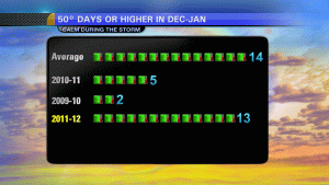
I put together this graphic for the noon show today, showing the difference over the last few years with the number of 50° days in KC. The average, which may surprise you for DEC-JAN is 14. Needless to say we should eclipse that number in the next week or so, and do it easily I think. Keeping in mind that we’re only 1 week done with JAN that is!
 it’s really impressive when you see just how “rough” we’ve had it for the last couple of years.
You may notice on the internet or see in the newspaper or hear from the media about hundreds of record highs that have been set in the last week or so. There are various reports of close to 1000. The thing about this statement, and something that I emailed NOAA about today, since it’s been running around the Twitter world and also being talked about on The Weather Channel, is that while technically true, its stretching the truth somewhat. It should be noted, and one of the folks @ NOAA said I had a good point with my issue, that many of these “records” only go back 30-50 years or so. For example, since KCI is the “official” reporting station for KC, technically yesterday we established a new record high @ KCI with 65° since the airport has only been open since the early 70s. The thing is the weather records for KC go back to the 1880s. Granted the “official” reporting station has moved around a bit over the last century + but when you ask the NWS what the record high is on 1/5, they will tell you it’s 68° set back in 1956 not 59° that the airport (KCI) had in 2008. Yet this was included int he record highs yesterday, when in reality KC didn’t set a record. This same occurrence happened at many of the reporting stations used in tabulating the record information.
Taking this one step farther…if you go to the NCDC website that keeps tracks of daily records (neat site!) and see how many record highs there were yesterday, you come up with 336. Now when you parcel out some of the smaller stations with fewer years of record history, i.e. KCI, and recalculate the data, the number shrinks down to 66 records tied or broken, and even some of that data still has those pesky shorter period of record stations contained in it.
Obviously I’ve delved into the minutia of records for you, and this, in the scheme of things the whole thing really isn’t that big of a deal, but when you see newspaper/media reports about almost 1000 or more record highs being set in the US since last week, just remember that in my opinion, there should be an asterisk next to the number of record highs.
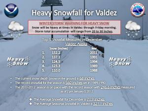
So with so much talk about the warmth, lets look for at least one area of the USA that actually is having a rough winter…for that we have to go all the way up towards AK and especially N AK where snowfall is out of control up there!
That’ll do it for the PM update…now back to the original AM posting!
While temperatures today are going to be somewhat cooler than yesterday, we’re still looking at highs some 20° above average for this time of the year, and while no record highs are coming again anytime soon, we’re still going to be on the “mild” side of things through the middle of next week.
Yesterday was truly phenomenal day day across many areas of the Midwest and the western part of the country. Record highs were established not only for the day but for the month of January which is very impressive. In MN they had never had 60° readings during the 1st week of JAN…until yesterday when several cities reported 60°+ temps. Rapid City, SD hit a record of 73° which was 4° warmer than Miami, FL. Other cities in SD set records as well.

The amazing thing about some of these records are that they were were broken by almost 20°. I can’t tell you how amazing that is the the world of weather.Phillip, SD hit 74° yesterday eclipsing the old record of 46° by almost 30°!!!!!!
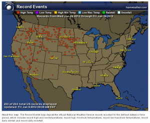
Closer to home, Topeka hit 70° and St Joe hit 64° for record highs. Here is a look at all the different records for the last couple of days.
 Meanwhile these records are also a factor out west. We’ve talked a bit about the weather out towards S Lake Tahoe…and for that matter the Reno area as well…
It should be noted that the period of record for S Lake Tahoe is “only” about 45 years…which in the world of weather records is not that long of a time period.
As far as the forecast goes, we continue to expect a significant change in the weather WED-FRI of next week. Temperatures look to drop during the day on WED and have a tough time recovering on THU and it’s likely that the highs on THU will only be in the 20s. Now a lot of TV folk will be making a HUGE deal out of this, and in the context of what we’ve enjoyed this winter, this next shot of cold air will be significant, but lets also try and keep some perspective about it. It’s almost the middle of JAN, this will be the coldest part of the year, on average, for KC. This is SUPPOSED to happen. 20s for highs and single digits for lows are “normal” (I hate that word for weather) for KC. It should be noted that there will be several surges of Canadian and Arctic air over the next few weeks and the weather for the last half of the month will be significantly different than the first 10 days of the month.
Here is the 5K foot temperatures, showing the surge of colder air moving through…these temperatures are in °C. (EURO model)

That airmass will move away next weekend and then another will move in after the 15th. Still no significant precip…rain or snow is expected around here for quite some time.
Have a great Friday and I’ll update you again this afternoon.
Joe


